- RedZoneApp (x)
- Search results
Search results
Islandora sort
Showing 61 - 80 of 2,888 results.
- dc.title
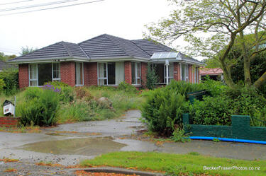
- BeckerFraserPhotos December 2011 photograph 1086
- dc.description
- A photograph captioned by BeckerFraserPhotos, "A residential property on Irene Street in the Horseshoe Lake district".
- Date
- 1:38am 15th December 2011
- Tags
- RedZoneApp, Horseshoe Lake, Irene Street, residential red zone, Burwood
- dc.title
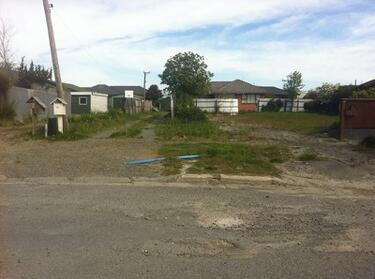
- BeckerFraserPhotos May 2013 photograph 118
- dc.description
- An abandoned residential property at 19 Waygreen Avenue in New Brighton. The section is overgrown with weeds. A single brick fence post remains standing. The gutter has flooded.
- Date
- 11:34pm 20th May 2013
- Tags
- RedZoneApp, Waygreen Avenue
- dc.title
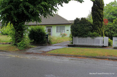
- BeckerFraserPhotos December 2011 photograph 1638
- dc.description
- A photograph captioned by BeckerFraserPhotos, "A residential property on Halberg Street in Dallington".
- Date
- 4:07am 15th December 2011
- Tags
- RedZoneApp, Halberg Street, residential red zone, Avonside
- dc.title
- BeckerFraserPhotos December 2011 photograph 1710
- dc.description
- A photograph captioned by BeckerFraserPhotos, "An earthquake-damaged property on Locksley Avenue".
- Date
- 4:24am 15th December 2011
- Tags
- RedZoneApp, Avonside, Locksley Ave, residential red zone, Avon River
- dc.title
- BeckerFraserPhotos December 2011 photograph 1854
- dc.description
- A photograph captioned by BeckerFraserPhotos, "A residential property on River Road".
- Date
- 4:37am 15th December 2011
- Tags
- RedZoneApp, Avonside, residential red zone, River Road, Avon River
- dc.title
- BeckerFraserPhotos September 2010 photograph 078
- dc.description
- A photograph of road signs and a cone on Avonside Drive. One sign indicates that the speed limit in the area is temporarily 30 km/h. The other states that there is "No through route. Access to properties only".
- Date
- 1:48am 14th September 2010
- Tags
- RedZoneApp, road, sign, Avonside
- dc.title
- Photograph by Neil Macbeth 405
- dc.description
- Students from the University of Canterbury heading back to work after enjoying a barbeque lunch in Burwood Park. The students have volunteered to clear liquefaction from Christchurch properties as part of the Student Volunteer Army.
- Creator(s)
- Neil Macbeth
- Date
- 12:56am 2nd March 2011
- Tags
- RedZoneApp, Student Volunteer Army, liquefaction, BBQ, barbeque, Community, SVA
- dc.title
- BeckerFraserPhotos July 2011 photograph 260
- dc.description
- A photograph of the Medway Street bridge.
- Date
- 1:05am 9th July 2011
- Tags
- RedZoneApp, River Avon, wobbly bridge, Avonside Drive
- dc.title
- BeckerFraserPhotos December 2011 photograph 0389
- dc.description
- An aerial photograph of the Horseshoe Lake residential area in Burwood.
- Date
- 6:31am 14th December 2011
- Tags
- RedZoneApp, Burwood, Horseshoe Lake, Horseshoe Lake area, residential red zone, aerial
- dc.title
- BeckerFraserPhotos December 2011 photograph 0926
- dc.description
- A photograph captioned by BeckerFraserPhotos, "Residential properties on Goodman Street in the Horseshoe Lake district".
- Date
- 1:26am 15th December 2011
- Tags
- RedZoneApp, Goodman Street, Horseshoe Lake, residential red zone, Burwood
- dc.title
- Julia Holden's 2012 Photographs 108
- dc.description
- A photograph of abandoned properties on Birch Street in Bexley.
- Creator(s)
- Julia Holden
- Date
- 4:01pm 1st November 2012
- Tags
- RedZoneApp, abandoned, residential red zone, Birch Street, Bexley
- dc.title
- Julia Holden's 2012 Photographs 118
- dc.description
- A photograph of an abandoned property at 72 Waitaki Street in Bexley. The driveway is flooded with stagnant water.
- Creator(s)
- Julia Holden
- Date
- 4:20pm 1st November 2012
- Tags
- RedZoneApp, abandoned house, residential red zone, Waitaki Street, flooding, Bexley
- dc.title
- 22 February Earthquake - Photograph 25
- dc.description
- Damage to a house in Richmond. The brick wall is badly cracked and twisted, and some bricks have fallen, exposing the lining paper and framing below. The driveway is cracked and covered in liquefaction. The photographer comments, "These photos show our old house in River Rd and recovery work around Richmond and St Albans. Does that wall look straight to you?
- Creator(s)
- Gregor Ronald
- Date
- 10:24pm 23rd February 2011
- Tags
- RedZoneApp
- dc.title
- Photograph by Jocelyn Kinghorn 327
- dc.description
- Damage to a block of flats, with silt from liquefaction around the footpath, and road cones outside the property. The fence has been spray painted with the words "All units damaged. Keep out".
- Creator(s)
- Jocelyn Kinghorn
- Date
- 4:43am 27th January 2011
- Tags
- RedZoneApp, Community
- dc.title
- Photograph by Neil Macbeth 406
- dc.description
- Students from the University of Canterbury heading back to work after enjoying a barbeque lunch in Burwood Park. The students have volunteered to clear liquefaction from Christchurch properties as part of the Student Volunteer Army.
- Creator(s)
- Neil Macbeth
- Date
- 12:57am 2nd March 2011
- Tags
- RedZoneApp, Student Volunteer Army, liquefaction, BBQ, barbeque, Community, SVA
- dc.title
- We Lived Here: Oxford Terrace Photograph 137
- dc.description
- A photograph of the former site of the houses at 422, 424, and 426 Oxford Terrace. The houses were demolished after the land was zoned Red. Grass has begun to grow over the sites.
- Creator(s)
- Juliet Nicholas
- Date
- 9:52pm 14th November 2013
- Tags
- RedZoneApp, Oxford Terrace, Avon Loop, grass, residential red zone, Community, We Lived Here
- dc.title
- We Lived Here: Oxford Terrace Photograph 034
- dc.description
- A photograph of the former site of the Locke family's house at 392 Oxford Terrace. The Locke's house was deconstructed after their land was zoned Red. The photographer comments, "The house was deconstructed and rebuilt on another site".
- Creator(s)
- Juliet Nicholas
- Date
- 10:47pm 3rd July 2013
- Tags
- RedZoneApp, Avon Loop, residential red zone, Locke, Community, We Lived Here, RedZoneApp, Oxford Terrace
- dc.title
- We Lived Here: Oxford Terrace Photograph 105
- dc.description
- A photograph of the earthquake damage to a section of Robin Duff's house at 386 Oxford Terrace. The chimney has fallen off the roof and is now resting in the patio. Behind the chimney, one of the walls has a noticeable lean and the glass of one of the French doors is broken. The photographer comments, "The glass was broken by looters who entered the house and took bits that interested them".
- Creator(s)
- Juliet Nicholas
- Date
- 8:58pm 14th November 2013
- Tags
- RedZoneApp, Oxford Terrace, Robin Duff, Avon Loop, French door, glass, chimney, house, Community, We Lived Here
- dc.title
- Overgrown property in Bexley
- dc.description
- Overgrown property in Bexley, Christchurch.
- Creator(s)
- Jared Cantlon
- Date
- 10:36pm 15th January 2012
- Tags
- RedZoneApp, Community
- dc.title
- Photograph by Neil Macbeth 344
- dc.description
- A digger collecting liquefaction from the side of Fleete Street, near Birchfield Avenue in Dallington.
- Creator(s)
- Neil Macbeth
- Date
- 4:08am 27th February 2011
- Tags
- Birchfield Avenue, Fleete Street, liquefaction, digger, Community, Dallington, RedZoneApp


