Search results
Islandora sort
Showing 21 - 40 of 43 results.
- dc.title
- Fairfax Video, June 2014 (5)
- dc.description
- A video of an interview with Robyn Simpson about her property in the Flockton Basin. Simpson had to leave her house after flooding made in unliveable. This video was part of a series of videos about residents in the flood-prone Flockton Basin.
- Date
- 2:02am 2nd June 2014
- Tags
- Robyn Simpson, flood, flooding, Flockton Basin, Media, Communications and Journalism
- dc.title
- Fairfax Video, June 2014 (4)
- dc.description
- A video of an interview with Pamela Wilkinson about her property in the Flockton Basin. Wilkinson had to leave her house after flooding made in unliveable. This video was part of a series of videos about residents in the flood-prone Flockton Basin.
- Date
- 1:59am 2nd June 2014
- Tags
- Pamela Wilkinson, flood, flooding, Flockton Basin, Media, Communications and Journalism
- dc.title
- Fairfax Video, April 2014 (1)
- dc.description
- A video of interviews with residents of Carrick Street about the constant flooding. Babu Chatterji, Adam Smith, and Pip Thurlow are interviewed. The residents talk about how the increase in flooding since the earthquakes, how the flooding is affecting their lives, and the lack of help from the authorities.
- Creator(s)
- Georgina Stylianou
- Date
- 2:09am 30th April 2014
- Tags
- flood, flooding, Carrick Street, Babu Catterji, Adam Smith, Media, Communications and Journalism
- dc.title
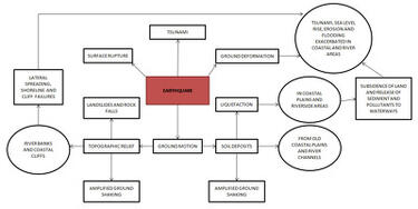
- Vulnerability to Seismic Hazards in Coastal and Riverside Communities, map number 5
- dc.description
- A flow chart depicting potential hazards earthquakes pose to coastal geography.
- Creator(s)
- Nick Brunsden
- Tags
- landslides, rock falls, ground motion, amplified ground shaking, liquefaction, tsunami, surface rupture, ground deformation, erosion, flooding, coastal plains, riverside areas, subsidence, sediment, waterways, lateral spreading, shoreline
- dc.title
- Fairfax Video, June 2014 (2)
- dc.description
- A video of an interview with Hamish Griffen and Leila Chrystall about their property in the Flockton Basin. Griffen and Chrystall had to leave their house after the flooding made it unliveable. This video was part of a series of videos about residents in the flood-prone Flockton Basin.
- Date
- 1:47am 2nd June 2014
- Tags
- Hamish Griffen, Leila Chrystall, flood, flooding, Flockton Basin, Media, Communications and Journalism
- dc.title
- Jim Baltaxe WEMO Photograph 060
- dc.description
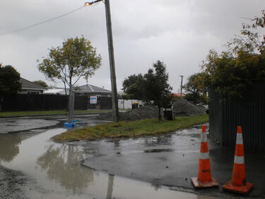
- A photograph of flooding on a residential street in Christchurch. Large piles of gravel have been placed along the street with cordon fences in front of them. Road cones can be seen in the foreground.
- Creator(s)
- Jim Baltaxe
- Date
- 1:38am 7th March 2011
- Tags
- road cone, cordon fence, gravel, flooding, Government and Politics
- dc.title
- BeckerFraserPhotos April 2011 photograph 471
- dc.description
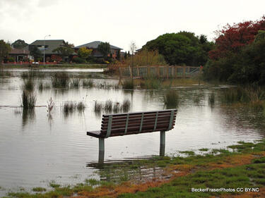
- Photograph captioned by BeckerFraserPhotos, "This is a very high tide in the Avon River, but shows how the danger of flooding has increased".
- Date
- 5:09am 18th April 2011
- Tags
- flooding, Avon River, subsidence, very high tide, Burwood, RedZoneApp
- dc.title
- WEMO ERT Set 3 - February 2011 - Photograph 210
- dc.description
- A photograph looking into the basement of the Copthorne Hotel. Rolls of carpet and chairs are sitting in a pool of water.
- Date
- 3:16am 1st March 2011
- Tags
- Copthorne Hotel, carpet, chair, basement, flooding, Kilmore Street, Durham Street, Copthorne, hotel, Government and Politics
- dc.title
- Nic Johns and Mark Osborne WEMO Photograph 066
- dc.description
- A photograph of a map at the temporary Civil Defence headquarters which was set up at the Christchurch Art Gallery after the 4 September 2010 earthquake. The map shows areas of the city that have flooded and roads that have closed.
- Creator(s)
- Mark Osborne, Nic Johns
- Date
- 9:37am 13th September 2010
- Tags
- Christchurch Art Gallery, Civil Defence, map, flooding, road closures, Government and Politics
- dc.title
- Fairfax Video, February 2011 (4)
- dc.description
- Aerial footage of Christchurch recorded the day after the 22 February 2011 earthquake. The footage shows damage to the Smith City car park, the Cathedral of the Blessed Sacrament, the CTV Building, the PGC Building, the Durham Street Methodist Church, the Lyttelton Timeball Station, the roads alongside the Avon River, and the ChristChurch Cathedral. It also shows New Zealand Army road blocks outside the hospital, crushed buses on Colombo Street, a Royal New Zealand Navy vessel in Lyttelton Harbour, rock fall on the Summit Road, collapsed cliffs in Sumner and Redcliffs, tents set up in a park, flooding in New Brighton, and liquefaction in QEII Park.
- Creator(s)
- Daniel Tobin
- Date
- 2:23am 23rd February 2011
- Tags
- aerial, Cathedral of the Blessed Sacrament, ChristChurch Cathedral, Lyttelton, Lyttelton Timeball, cordon, hospital, Summit Road, flooding, New Brighton, QEII, liquefaction, Durham Street Methodist Church, CTV, PGC, bus, Queen Elizabeth II Park, Media, Communications and Journalism
- dc.title
- Fairfax Video, March 2014 (3)
- dc.description
- A video of an interview with Kristal and Justin Thompson, about their house on Carrick Street which was damaged by the floods. Justin talks about how the 2010 and 2011 earthquakes has caused their land to drop. Kristal also talks about their insurance scheme.
- Creator(s)
- Daniel Tobin
- Date
- 1:43am 7th March 2014
- Tags
- flooding, flood, Kristal Thompson, Justin Thompson, Carrick Street, insurance, Media, Communications and Journalism
- dc.title
- Jim Baltaxe WEMO Photograph 059
- dc.description
- A photograph of piles of liquefaction on the side of Pages Road. Flooding in front of a driveway can be seen. Cordon fences are propped up against a fence.
- Creator(s)
- Jim Baltaxe
- Date
- 1:37am 7th March 2011
- Tags
- Pages Road, liquefaction, cordon fence, flooding, Government and Politics
- dc.title
- Rebekah Rogers WEMO Photograph 052
- dc.description
- A photograph of the earthquake damage to the corner of Woodham Road and Avonside Drive. There are large cracks in the road, and flooding and liquefaction. Wire fencing and road cones have been placed around parts of the road that are unsafe. Two signs reading, "Road closed" and, "No entry" can be seen at the entrance to Avonside Drive.
- Creator(s)
- Rebekah Rogers
- Date
- 6:57am 7th March 2011
- Tags
- RedZoneApp, Avonside Drive, crack, sign, cordon fence, road cone, liquefaction, flooding, Government and Politics, Woodham Street
- dc.title
- Empowered Christchurch Letter to Gerry Brownlee 1
- dc.description
- A copy of a letter from Empowered Christchurch which was sent to Gerry Brownlee, Minsiter for the Canterbury Earthquake Recovery, on 15 April 2014. The letter lodges an Official Information Act request about the remediation of land that is subject to liquefaction and flooding.
- Date
- 12:00pm 15th April 2014
- Tags
- Empowered Christchurch, Gerry Brownlee, OIA, Official Information Act, land remediation, liquefaction, flooding, letter, Government and Politics
- dc.title
- Fairfax Video, March 2014 (2)
- dc.description
- A video of an interview with Kim Evans, manager of the Shirley Bakery, about the flooding of her store. Evans describes the flood damage as being worse than the damage caused by the 2010 and 2011 Canterbury earthquakes.
- Creator(s)
- Daniel Tobin
- Date
- 11:51pm 5th March 2014
- Tags
- Kim Evans, Shirley Bakery, flooding, Media, Communications and Journalism
- dc.title
- Rebekah Rogers WEMO Photograph 043
- dc.description
- A photograph of liquefaction and flooding in a residential street in Christchurch.
- Creator(s)
- Rebekah Rogers
- Date
- 6:35am 7th March 2011
- Tags
- liquefaction, flooding, Government and Politics
- dc.title
- Julia Holden's 2012 Photographs 114
- dc.description
- A photograph of an empty, overgrown section on the corner of Orari and Waitaki Street in Bexley.
- Creator(s)
- Julia Holden
- Date
- 4:18pm 1st November 2012
- Tags
- Bexley, residential red zone, Orari Street, swamp, flooding
- dc.title
- Fairfax Video, June 2014 (1)
- dc.description
- A video of an interview with Rose Lennon about her property in the Flockton Basin. Lennon's house has been damaged by flooding in the area. This video was part of a series of videos about residents in the flood-prone Flockton Basin.
- Date
- 1:44am 2nd June 2014
- Tags
- Rose Lennon, flood, flooding, Flockton Basin, Media, Communications and Journalism
- dc.title
- Julia Holden's 2012 Photographs 117
- dc.description
- A photograph of an abandoned property at 72 Waitaki Street in Bexley. The driveway is flooded with stagnant water.
- Creator(s)
- Julia Holden
- Date
- 4:20pm 1st November 2012
- Tags
- RedZoneApp, abandoned house, residential red zone, Waitaki Street, flooding, Bexley
- dc.title
- Julia Holden's 2012 Photographs 111
- dc.description
- A photograph of an abandoned property at 72 Waitaki Street in Bexley. The driveway is flooded with stagnant water.
- Creator(s)
- Julia Holden
- Date
- 4:14pm 1st November 2012
- Tags
- RedZoneApp, abandoned house, residential red zone, Waitaki Street, flooding, Bexley


